

The next time I found myself back on Te Araroa, July 2017, winter had come – inasmuch as it ever comes to the gentle north.
This time I had a companion for the first week or so; she was stoked to be having her first taste of Te Araroa.
We left my car in Waipu and my old friend Nick dropped us at the dairy I’d reached last time.
Day 9 – Mangamuka dairy to Apple Dam campsite: 12km.
To get into the Omahuta-Puketi forest you have to walk up some gravel roads.
Now, some Te Araroa walkers organise rides for these connecting road sections, which do crop up fairly often; and Nick did offer. But I’m determined to walk every step of Aotearoa, even if I’m 100 when I shamble into Bluff.
And it was a nice way to start this stint. Omahuta-Puketi is pretty demanding, as it takes two full days to get through, and there’s a long section of creek-wading that’s too dangerous to attempt after recent rain.
So it was good to begin with a gentle saunter along sunny gravel roads through farmland and regenerating bush.
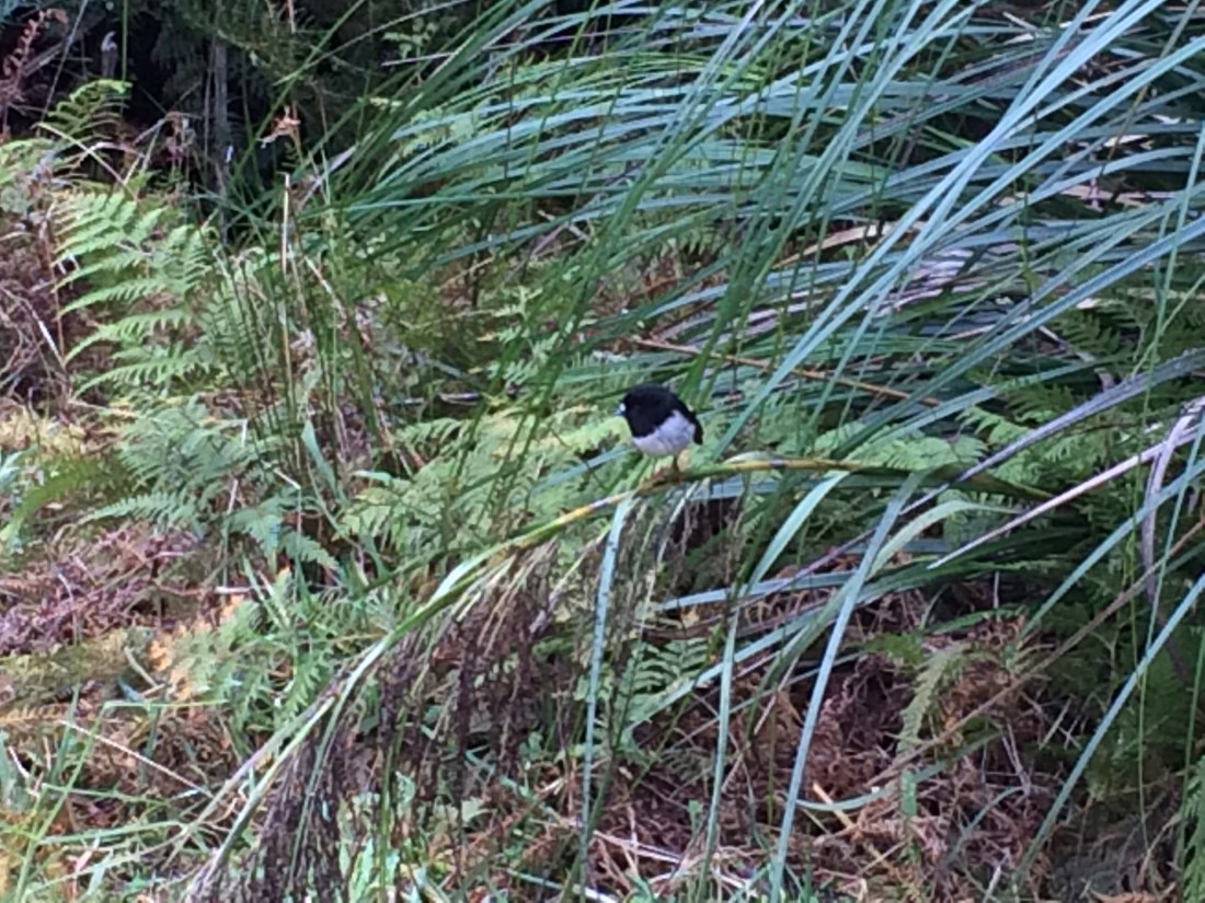
By early afternoon we’d dropped down into a sheltered spot known as Apple Dam campsite. We put up our tent and made the acquaintance of a chorus of native birds – kereru, tui, bellbirds and this guy.
Day 10 – Apple Dam to Pukatea Ridge Track. 12 km.
In the morning we followed four-wheel-drive tracks to a a long, grassy ridge, which took us down into a long canyon formed by the Mangapukahukahu stream.
The weather had been pretty clear, so on we strode.
It’s delightful to splosh along from pool to pool, the thick, cool bush all-enveloping on every side, unspoiled even by a track, nor markers.
It’s usually around ankle to knee deep, and occasionally up to thighs or waist.
After a few kilometres we reached a junction with the deeper, swifter Waipapa River, and stopped for lunch on the warm, grey river stones.
Then a track takes you on a scrambly, muddy sideways sidle along the Waipapa’s steep bank to the foot of the Pukatea Ridge.
The trail notes ask trampers to try to avoid camping anywhere in the forest except Apple Dam; but that would have made today a rugged, 25-kilometre epic, which was beyond us.
Now that it was winter there were only 10 hours or so of daylight, and it was getting dark already.
So we camped there, in a silent, stately grove beside the Waipapa. I had a fantastic evening dip in the very clean, very chilly river while my trail buddy giggled at my frozen shrieks.
Day 11 – Pukatea Ridge Track to Puketi Rd-Waiare Rd junction. About 18km.
We were both fairly creaky in the morning. One of the drawbacks of section-hiking a long-distance trail, is that every time you start a new section, you have to get trail-fit again.
And sleeping on a thin mat on a forest floor in winter makes your creakier.
But we downed coffee and peanut butter, and ploughed on up the narrow ridge through the high, sighing, silvery trees.
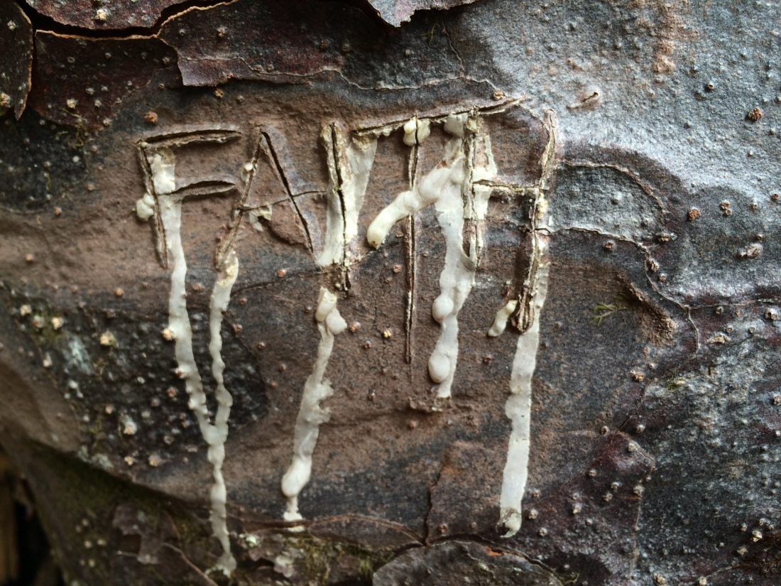
On the way up we found the skeleton of a large tree, just a dead, rotting trunk; it had been killed, completely suffocated by two huge creepers-turned-trunks, that had grown up around it, creating a living exo-skeleton for a dead host.
In the sap-filled bark of one of the blended stranglers, someone had carved a single, redolent word:
At the top of the ridge we came out onto Pirau Ridge Road; we bowled along in the balmy winter day for 9km, talking about everything under the sun and meeting the occasional cyclist or hunter.
Finally we reached the Puketi Forest Headquarters, where there’s a DOC campsite and hut. It was only mid-afternoon, so we filled up with water and pressed on; we hoped to get to a secluded spot to camp further down toward Kerikeri.
The route over farmland towards that spot was closed for lambing; we’d have to take a detour via gravel roads.
We went as far as daylight allowed and put up our tent on the grassy roadside. We ate, had a hot drink, and crawled into our sleeping bags as rain began to pour.
Day 12 – Puketi Rd-Waiare Rd junction to Kerikeri. About 20km.
A long, rainy day of road-slogging awaited. It was gravel, which is easier on your joints and feet than tar-seal; but it’s still punishing, and can be a bit boring – especially in the rain.
But it’s all part of the journey, and we still had plenty to yak about, and on we trekked.
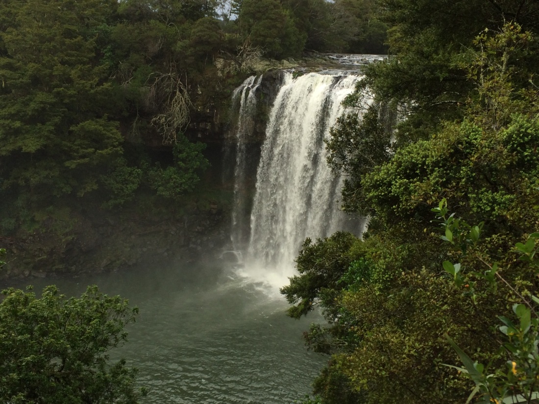
Finally the Puketotara Road joins the main road into Kerikeri. Then a lovely undulating trail leads you off that, along the Kerikeri river, past houses and farmland and finally through luxuriant native bush to the full-throated Rainbow Falls:
We’d reached the Bay of Islands: one of the country’s biggest tourist draw-cards, as well as a historical touchstone. It was the site of some of the first sustained interactions between Māori and Pākehā, especially missionaries.
It was here the Treaty of Waitangi, the country’s foundational document, was signed.
Appropriately enough, we booked a room at the Hone Heke Hostel in Kerikeri’s town centre. Heke is arguably the emblematic Bay of Islands character, a thoughtful man of action, shaken out of his missionary education by his frustration with Pākehā encroachment on Māori land, self-determination and freedom. He responded by repeatedly chopping down the main local flagpole, no matter how they tried to defend it, because it flaunted the “Butcher’s Apron”: the Union Jack.
He got hunted for it, but it was a beautifully simple, eloquent piece of direct action which still resonates loudly down the years.
After checking in to the Hone Heke we went out for beer and burgers, joyfully devouring them like starving trail-beasts.
Our tent, sleeping bags, clothes and everything was pretty wet, but dried off overnight in front of the hostel’s log fire.
Day 13 – Kerikeri to Paihia: 23km.
As we pushed on toward Paihia in the morning, a thunderstorm rolled through and we got briefly pelted with heavy hail stones. But soon it cleared, and then we were under the protective canopy of a pine forest.
A carpet of rust-coloured needles muffled the forestry road that drew us slowly up and over the ridge between the towns; occasionally there was a flash of blue from the bay below.
We didn’t actually find it, but up here somewhere there’s a stone marking the opening of the first section of Te Araroa track, in 2014. We were too tired right then for a detour, but I would have liked to have seen it, because it involves poetry.
The trail notes say it has these lovely lines on it, from the great A.R.D. Fairburn’s poem, “To a Friend in the Wilderness”:
I could be happy, in blue and fortunate weather,
Roaming the country between you and the sun.
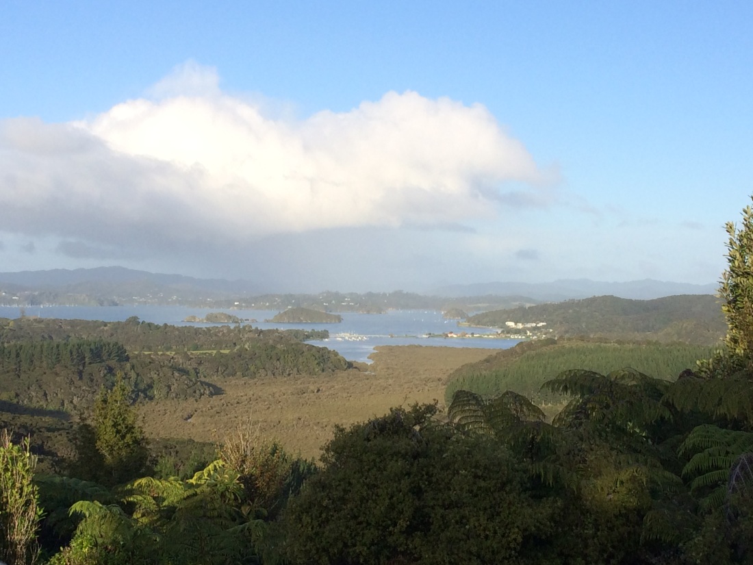
We came out in the afternoon to a golden view – here it was at last, the actual bay of the Bay of Islands:
Then the trail led us down to Waitangi, which in my opinion is the most important place in Aotearoa/New Zealand.
Te Araroa goes right by the Treaty Grounds where, every year, this country celebrates being formed not through a brutal war of independence, nor through a violent genocide, but through a dialogue, and a document – albeit an imperfect document, and at times a dishonoured one.
(And not to say there wasn’t violence and brutality, both before and after the Treaty was signed, particularly from the colonisers; Te Araroa takes walkers right past some of its bloodiest sites, as I’ll blog about later).
It’s a difficult document, the Treaty of partnership between Māori and Pākehā signed in1840. It forces us, if we take it with any kind of seriousness, to ask ourselves uncomfortable questions, not just on Waiting Day but every day – that’s if we want to be a decent, grown-up community. But I reckon that’s part of what makes a unique document, and a potentially powerful one, and one worth celebrating.
That’s what was on my mind as we marched along past the Treaty grounds in the dark of the midwinter evening, towards the lights of Paihia.
Soon you cross a bridge, and then you’ve got the long white waves on the sandy beach for company as you plod into town.
We booked into the YHA and headed out, ravenous again, for pizzas and beer. We ate and drank on a wooden platform under a pōhutukawa, overlooking the soft-sighing surf and the lights of the yachts as they lay quiet on the dark harbour.
Munching, we saw a large man with a box of Double Browns under his arm lurch towards us. Here we go, we thought. But all he said was: “Aha, very good, hello, hello. How’s it all going here, then?”
We said it was all going very fine, thank you, and he nodded slowly, contentedly, surveying us and beaming. Then he turned away with a gentle lurch to wait for his friend, who was emerging from a bush and jogging to catch up, buttoning his fly; somewhat awkwardly, given he also carried a box of “dough-bros”.
As they walked away we heard the first bloke, big, bluff and amused by life, resume the conversation the other’s piss in the bushes had presumably interrupted: “So. Tell me everything I need to know about your sister.”
Day 14 – Paihia to Russell Forest, 23km.
In the morning we had a well-earned sleep-in; we were kayaking the next bit, and the tides called for a midday start.
We resupplied at the Paihia supermarket, and took the ferry over to Russell – where Heke chopped his way into legend – to get a gas cylinder for my camping stove from Hammer Hardware.
Then we went down to the Paihia beach with our packs to meet Dan from Bay Beach Hire. This firm have an agreement to rent sea kayaks to Te Araroa trampers for the stretch down the Waikare inlet, saving us a long road slog.
They take your pack down to the end of the inlet, close to an hour’s drive away, and swap it for the kayak.
From memory it cost about $100, which I thought was pretty good value.
We climbed aboard our red tandem kayak and headed out into the beautiful bay.
You get a sea-level view of some amazing baches, some palatial, some quaint and rustic; also thousands of yachts, and secluded islands.
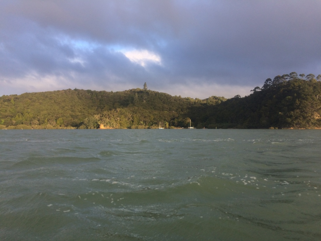
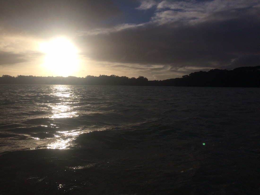
We had a picnic lunch on a beach on the way, and a cruise through some mangroves; watched the sinking sun make the water gleam.
Dan keeps in contact with you via cell phone; and when you pass a certain point he sets off to pick you up.
Waikare is isolated, almost otherworldly in its remote stillness. There’s a muddy boat ramp beside a cattle yards; and a gravel road disappearing into steep, bushy hills.
It was the end of the road for my lovely companion. She was going back to Paihia with Dan and the kayaks, and then back to Wellington in the morning. I had more time off, and was carrying on for another two weeks.
It was strange and a little sad to find myself suddenly alone as the car disappeared into the silent dusk.
There was nothing else to do, though, but step off up the darkening road.
Where the gravel ends there’s a ford over a river; I went another k or so on the deteriorating track, then found a flat spot in a grove of ponga trees, and set up my little tent.
We’d done 100km in six days. Russell Forest breathed around me.
